Harvesting crop data from space to increase climate and nutrition security

Published by:
Focus Region:
Global
Focus Topic:
Information Technologies
Knowledge Management
Climate / Weather / Environment
Nutrition / Food Systems

Changes in planting and harvesting seasons, variable and extreme weather events, and increased water risks are making countries increasingly vulnerable. Robust and systematic monitoring of nutrition and climate from space is a critical support to resilience building.


As the crew of Apollo 13 famously understated when their spacecraft was shaken by an onboard explosion 300,000 km above the earth — we have a problem.

The latest State of Food Security and Nutrition in the World Report warns that almost 9% of the world’s population is undernourished. Almost 20% of these undernourished people are in Africa and, despite recent progress towards achieving Zero Hunger over the last few years, more than 50% are in Asia. If these numbers are not devastating enough, consider that they do not yet include the 100 million people expected to be driven into extreme poverty by the end of 2020 by the COVID-19 pandemic which has, according to the Global Commission on Adaptation, “tragically exposed the risks that humanity faces and how unprepared we are to respond.”

One of those risks is how the climate crisis is affecting our farmers’ ability to grow nutritious food.

Changes in planting and harvesting seasons, variable and extreme weather events, and increased water risks are making countries increasingly vulnerable. Even small fluctuations can be devastating when you are dependent on your harvest for your food and nutrition security. All this on a planet whose boundaries are being pushed beyond the limits when it comes to environmental damage. That we need to change the trajectory of our food systems is abundantly clear.

SPACE TO EARTH — ARE YOU RECEIVING?

The Apollo 13 astronauts managed to navigate their perilous way home, guided by real-time information sent from the ground by the NASA team at Mission Control. Today information arriving from observation satellites orbiting miles above the earth is guiding actions to avoid or reduce the risks of a nutrition crisis back here on earth – a risk that has been tragically exposed by the COVID-19 pandemic which has shown just how unprepared we can be to respond to threats to people’s health, well-being, and livelihoods.

Deploying environmental data available free via Google Earth Engine, scientists from the International Water Management Institute (IWMI) and the CGIAR Research Program on Water, Land and Ecosystems (WLE) have developed a map that shows the state of maturity of 40* crops that are critical for food and nutrition security around the world.

By estimating the nutrition values contained in those crops, and overlaying information about their maturity along with current and future climate data, and economic data, the scientists can map a global scale of nutrition risk levels to better manage risks, for example, water stress.

Source: IWMI


PLUGGING WATER RISK KNOWLEDGE GAPS

By connecting remote sensing global data on agricultural production (Spatial Production Allocation Model — SPAM) and water risk assessments (WRI), it is possible to zoom out to see that one-third of the world’s irrigated crop production is facing extreme water stress and water risks. According to the Water Resources Institute (WRI), more than 61 countries face high to extreme levels of water stress, which poses serious threats to human lives, livelihoods, and business stability.

It is also possible to compare risks at a national level. For example, in India, overall water risks are 40-45% compared to China with 30% and the USA with 12%. By narrowing that focus down even further to an individual crop, it is possible to make more nuanced risk assessments that consider nutrient and climate information, as well as how that maps to a country’s food security risk. For example, India is ranked 13th in terms of overall water stress for rice production, which, in 2019, was valued at US$7.1 billion and represented 32.5% of rice export globally. In addition, India’s population is three times bigger than that of the other 17 countries combined that are also ranked as extremely water stressed.

Connecting Water Stress and agriculture production and its impact on food security. Source: IWMI


Having almost real-time information allows better contingency measures. For example, farmers in India are using the South Asia Drought Monitoring System (SADMS) platform, developed and maintained by IWMI, to plan more effectively. This includes obtaining drought-tolerant varieties, supplementary irrigation, rainwater harvesting, and spraying potassium nitrate to relieve drought stress. Other measures to reduce climate risk include bundling resilient seeds with climate information and insurance, or crop diversification.

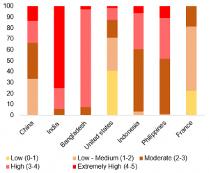
Knowing the global crop diversity (water Stress vs Resilience). Source: IWMI

THE MISSION AHEAD

It is abundantly clear that farmers are facing increasing water stress from climate change. Having more information in real time, such as which crops grow best where under current and future climates, as well as their nutrient and economic value, can help create strategies to reduce risk.

Robust and systematic monitoring of nutrition and climate from space has a critical role to play not just in understanding the cascading effects of climate change and how it impacts food and nutrition security among vulnerable smallholder farmers, but also how to help build resilience in the food systems of today. And beyond.


*Wheat, rice, maize, barley, pearl millet, small millet, sorghum, other cereals, potato, sweet potato, yams, cassava, other roots, beans, chickpea, cowpea, pigeonpea, lentil, other pulses, soybean, groundnut, coconut, palm oil, sunflower, rapeseed, sesame seed, other oil crops, sugarcane, sugarbeet, cotton, other fiber crops, arabica coffee, robusta coffee, cocoa, tea, tobacco, banana, plantain, tropical fruit, temperate fruit, vegetables — these crops are the only ones available at the moment to map as they have sufficient spatial resolution (9km).

SOURCE:
Thrive, a blog facilitated by CGIAR
AUTHORS:
Giriraj Amarnath and Samantha Collins
SUPPORT:
Indian Council of Agricultural Research (ICAR) and Japan’s Ministry of Agriculture, Forestry and Fisheries (MAFF)
COVER PHOTO CREDIT:
NASA