Evaluating satellite-based evapotranspiration estimates for hydrological applications in data-scarce regions: A case in Ethiopia
ABSTRACT
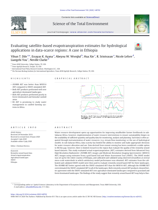
Water resource development opens up opportunities for improving smallholder farmer livelihoods in sub-Saharan Africa; however, implementation of water resource interventions to ensure sustainability hinges on the availability of sufficient quantity and quality data for monitoring, analysis and planning. Such data is often acquired through instrumentation of water resources (e.g. stream flow monitoring) or the use of hydrological models. In sub-Saharan Africa, data scarcity has limited the ability to monitor and make appropriate decisions for water resource allocation and use. Data derived from remote sensing has been considered a viable option to fill this gap; however, there is limited research in the region that evaluate the quality of the remotely sensed based datasets. This study evaluated actual evapotranspiration (AET) estimates derived from Advanced Very High Resolution Radiometer (AVHRR AET) images and Moderate Resolution Imaging Spectrometer (MOD16 AET) images using estimates from a grid-based Soil and Water Assessment Tool (SWAT). The SWAT model was set up for the entire country of Ethiopia, and calibrated and validated using observed streamflow at several meso-scale watersheds in which satisfactory model performance was obtained. AET estimates from the calibrated and validated SWAT model were then used to evaluate remotely sensed based AET for three landscapes. The AVHRR AET better agreed with the SWAT-simulated AET than the MOD16 AET, although the AVHRR AET overestimated the SWAT-simulated AET in all of the landscapes. Both remotely sensed AET products showed better agreement with the SWAT-simulated AET over agriculture dominated landscapes compared to grassland and forest dominated landscapes. The findings of the study suggest that remotely sensed based AET may help to fine-tune hydrological models in agricultural landscapes in data-scarce regions to improve studies on the impacts of water management interventions aiming to ensure environmental sustainability while enhancing agricultural production, and household income and nutrition.